KUALA LUMPUR – Sabah remains Malaysia’s most vulnerable region to earthquakes due to its proximity to active seismic zones, but experts caution that Peninsular Malaysia is not entirely risk-free either.
While the peninsula faces a lower threat, minor tremors have been recorded over the years, highlighting the need for continued vigilance.
Institute of Geology Malaysia’s president Abd Rasid Jaapar explained that earthquakes in Sabah are primarily triggered by the collision of the Philippine Sea Plate and the Eurasian Plate, as well as movements along local active faults.
“The risk is notably higher in Sabah, as it is closer to active seismic zones,” he told Bernama.
“Earthquakes are unpredictable in both location and magnitude. The risk exists – for instance, Bukit Tinggi once experienced a 3.8-magnitude earthquake. However, at present, there is no significant earthquake risk in the peninsula.”
“If we claim there is no risk at all, that would be inaccurate. Natural events like earthquakes are unpredictable, so we must remain cautious, but there is no need for undue concern,” he added.
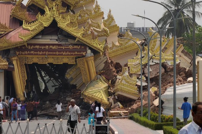
Yesterday, the United States Geological Survey reported that a powerful 7.7-magnitude earthquake struck Myanmar at a depth of 10km. Just minutes later, an aftershock measuring 6.4-magnitude hit the same area. The tremors were also felt in Chiang Mai and Bangkok, Thailand, and in Ho Chi Minh City, Vietnam.
The latest death toll of the Myanmar earthquake was recorded at 1,600 and counting as of yesterday.
Historically, Malaysia has also experienced strong earthquakes, particularly in Sabah, where quakes with magnitudes between 6.0 and 6.3 on the Richter scale were recorded in 1923, 1958, 1976, and 2015. In Sarawak, the strongest recorded tremor was a 5.3-magnitude earthquake in 1994.
Peninsular Malaysia has also witnessed several earthquakes, with epicentres in Bukit Tinggi, Pahang; Kenyir Dam, Terengganu; Kuala Pilah, Negri Sembilan; and Manjung and Temenggor in Perak. These quakes, ranging from magnitudes 1.6 to 4.6, occurred in 1984, 1985, 1987, 2007, 2009, 2010, and 2013, Bernama reported.
Meanwhile, National Disaster Management Agency director-general Datuk Khairul Shahril Idrus said that the Special Malaysia Disaster Assistance and Rescue Team (SMART) remains on high alert, regularly conducting disaster response exercises, particularly in high-risk areas in Sabah.
“Despite Malaysia’s location outside the Pacific Ring of Fire, Sabah, especially Mount Kinabalu, remains the most vulnerable area in the event of an earthquake. That is why SMART frequently conducts drills in the Mount Kinabalu region,” he said.
He added that SMART is internationally recognised by the United Nations (UN) for its world-class expertise in collapsed-building rescues and is equipped with state-of-the-art technology.
Meanwhile, the Meteorological Department director-general Dr Mohd Hisham Mohd Anip said that MetMalaysia currently operates 80 seismic sensors to monitor and detect earthquake activity across Malaysia and the surrounding region.
“So far, MetMalaysia has also deployed 83 tsunami sirens in tsunami-prone areas, nationwide. The Malaysian Tsunami Early Warning System is capable of relaying earthquake alerts to the public within eight minutes of detection,” he said.
Universiti Teknologi Malaysia Disaster Preparedness and Prevention Centre director Khamarrul Azahari Razak emphasised the need for the government to enhance cross-sectoral disaster preparedness, particularly among rescue agencies and emergency response teams.
“We must also consider evacuation strategies, response coordination and emergency measures, especially in relocating large populations to safer areas,” he said.
He noted that, since the 2015 Sabah earthquake, which claimed 18 lives, his team has been actively conducting disaster preparedness education in the state.
Meanwhile, the Malaysian Bumiputera Contractors Association president Datuk Azman Yusoff said that nearly all new high-rise buildings in Malaysia over the past decade have been constructed using earthquake-resistant materials and designs.
He said the government, through the Standards Department, has established earthquake-resistant building codes, including the “Malaysia National Annex to Eurocode 8: Design of Structures for Earthquake Resistance – Part 1: General rules, seismic actions and rules for buildings.”
One key element in Eurocode 8 is the use of spring isolators, which enable residential buildings, skyscrapers, and shopping malls to detach their foundations from ground movements. This flexibility helps absorb seismic energy, reducing the risk of structural collapse during earthquakes.
The Minerals and Geoscience Department introduced the Seismic Hazard Map of Peninsular Malaysia, Sabah, and Sarawak in 2019, as a mitigation measure to minimise earthquake-related risks.
The map serves as a reference for earthquake-resistant building designs, by classifying seismic hazard zones based on peak ground acceleration, ensuring safer construction practices in Malaysia. – March 30, 2025

